 Yesterday, Sunday, 1st October, was our Rangitoto day. We caught the nine-thirty ferry from Auckland and arrived on the island at about ten. From the jetty we walked west for a few hundred metres to have a look at the historic baches, chalet-style holiday homes built in the 20s and 30s (some of these are being preserved as little monuments to an older way of life). Then we walked back to the jetty and took the well-used footpath to the summit, a walk that took about an hour and that took us from sea-level to an elevation of about 260-metres. From the highest part of the rim of the crater (pay attention, you should know this by now, Rangitoto is a volcano) there are good views of Auckland, Devonport, the bridge, the harbour and the islands, not to mention Mission Bay. From the summit we walked east, towards the wharf at Islington Bay. Up to this point the weather had been fair, but from the slipway at Yankee Wharf back to the jetty used by the ferry it rained, quite hard at times. The first half of this part of the walk was also hard going, very rough underfoot and pushing through wet foliage too, so we were quite relieved to arrive back at the jetty, a bit tired and soaking wet to boot. Total distance walked, 13.2 km, nothing really, but over some rough ground. I kept a GPS track of the walk and plotted it on a 1:50,000 map, see the picture. Our track is the red line with the arrows showing the direction of travel. When we arrived back in Auckland the heavens opened, with thunder and lightning as well. According to the radio this morning there has been flooding and landslips in the Auckland region overnight, worse in the western parts. Anyway, the truth of it is that despite everything, including Anne falling over and cutting her knee on a lump of lava, we both enjoyed Rangitoto immensely.
Sunday, October 01, 2006
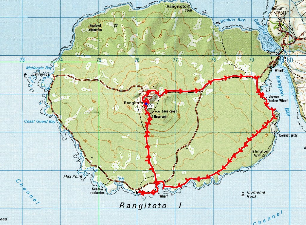
Yesterday, Sunday, 1st October, was our Rangitoto day. We caught the nine-thirty ferry from Auckland and arrived on the island at about ten. From the jetty we walked west for a few hundred metres to have a look at the historic baches, chalet-style holiday homes built in the 20s and 30s (some of these are being preserved as little monuments to an older way of life). Then we walked back to the jetty and took the well-used footpath to the summit, a walk that took about an hour and that took us from sea-level to an elevation of about 260-metres. From the highest part of the rim of the crater (pay attention, you should know this by now, Rangitoto is a volcano) there are good views of Auckland, Devonport, the bridge, the harbour and the islands, not to mention Mission Bay. From the summit we walked east, towards the wharf at Islington Bay. Up to this point the weather had been fair, but from the slipway at Yankee Wharf back to the jetty used by the ferry it rained, quite hard at times. The first half of this part of the walk was also hard going, very rough underfoot and pushing through wet foliage too, so we were quite relieved to arrive back at the jetty, a bit tired and soaking wet to boot. Total distance walked, 13.2 km, nothing really, but over some rough ground. I kept a GPS track of the walk and plotted it on a 1:50,000 map, see the picture. Our track is the red line with the arrows showing the direction of travel. When we arrived back in Auckland the heavens opened, with thunder and lightning as well. According to the radio this morning there has been flooding and landslips in the Auckland region overnight, worse in the western parts. Anyway, the truth of it is that despite everything, including Anne falling over and cutting her knee on a lump of lava, we both enjoyed Rangitoto immensely.
Subscribe to:
Post Comments (Atom)
No comments:
Post a Comment